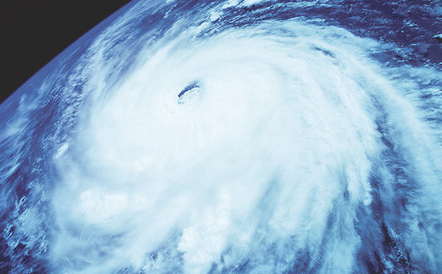
NEW IBERIA, La. (AL) – As 2017 nears the halfway mark, Acadiana residents are once again faced with the specter of a new hurricane season, which is slated to begin on June 1. And given the historic flooding the region, and the state, saw last year, in addition to the fact that it’s been nearly five years without a sizeable hurricane, it is now more important than ever to be prepared.
“There are two parts to the hurricane season,” says KATC Chief Meteorologist Rob Perillo. “Generally, it starts June 1 and ends Nov. 30, but for around here, the prime time for hurricane season is mid August through the first week of October. I’ve done the statistics and that’s when we have our most frequent and most intense hurricanes. That period–from the second or third week of August to the first week of October–that’s my prime time season. That’s when I plan not to do anything but be at work.”
According to Perillo, there’s no indication, one way or the other, about this year’s hurricane season forecast yet. However, according to noted forecaster Dr. Philip Klotzbach and Dr. Michael Bell of Colorado State University’s Department of Atmospheric Science, they anticipate that the 2017 Atlantic Basin hurricane season will have slightly below-average activity, mainly due to cooler Atlantic waters and the impacts of El Niño.
The phenomenon of El Niño occurs when the Pacific Ocean is abnormally warm off the coast of Peru. Warmer waters increase energy, which tends to increase the upper level winds over the Caribbean and Atlantic. In turn, this causes more wind shear, making it hard for storms to develop.
According to Klotzbach, his findings indicate that the current neutral El Niño-Southern Oscillation is likely to transition to either weak or moderate El Niño conditions by the peak of the Atlantic hurricane season. The tropical Atlantic has anomalously cooled over the past month and the far North Atlantic is relatively cold, potentially indicative of a negative phase of the Atlantic Multi-Decadal Oscillation. They anticipate a below-average probability for major hurricanes making landfall along the United States coastline and in the Caribbean.
The numbers that Klotzbach is forecasting for the upcoming hurricane season are: 11 named storms, 4 hurricanes and 2 major hurricanes.
“Guys like Klotzbach make an annual hurricane forecast for the Atlantic Basin, and his numbers, they’re going to all indicate near or a slightly below normal season,” says Perillo. “But I really don’t take any of those numbers to heart because last year it was a busier than normal season, but we didn’t see much of any activity in the Gulf, but for a weaker Category 1 hurricane over toward the Florida panhandle and we were slammed by an unnamed tropical-like system that wound up producing the worst flooding that we’ve seen since the 1940s.”
Perillo says that the March floods of 2016 in the Northern part of the state and down through the Toledo Bend and Sabine River Valley were the product of a warmer than normal spring. And that the second flood event down here last fall was tied to a weak, low pressure system that tapped a very deep moisture from the tropics that became a slow moving system that slogged over the region for that infamous two to three day period.
However, he adds that while there are indications that we might be heading back to an El Niño, usually the phenomenon doesn’t occur every year back to back, but rather every other year.
And just like all hurricane seasons, coastal residents need not be reminded that it only takes one hurricane to make landfall to make it an active season, so they should prepare the same for every season, regardless of how much activity is predicted.
“Whether it’s a busy season or not, I always say you need to be equally prepared each and every hurricane season for the possibility of flooding rainfall and then the hurricane risk that also includes an evacuation plan if you’re in a storm surge zone especially,” says Perillo.
Perillo adds that there are no current indicators that the season is going to get started any earlier than normal or later than normal or whether there’s going to be enough sheer presence that steers storms away from the coast.
“But statistically speaking, it’s been awhile since we’ve had a significant hurricane threat,” he says. “We have to go back to 2012 where we had Hurricane Isaac zip through between here and Baton Rouge, but it was not particularly a bad storm. And then you go back to 2008 to the Gustav/Ike affair and then back to Katrina/Rita in 2005. So, statistically speaking, we’re a little overdue for more tropical activity locally. But whether that comes to fruition or not no one can tell.”
The potential for more intense heavy rainfall is also something to consider given the record temperatures across North America last year.
“We saw the hottest year on record in Louisiana, in Lafayette rather, and much of the stations throughout Louisiana last summer,” says Perillo. “And when you have a hotter atmosphere you have more capacity to hold higher moisture content and that usually will translate to more frequent and more intense heavy rainfall events.
“And we’ve seen that bear out,” he adds. “The statistics all dictate that the likelihood of more frequent and more intense rainfall events, similar to but maybe not quite as bad as what we saw last August, is likely in our future. And it may not be this summer, but in the summers ahead for sure.”
The moral of this story is to begin preparing for any, and every, potential weather disaster starting June 1, which means having a reliable Hurricane Kit filled with batteries, candles, matches, flashlights and lanterns, crank radio and phone charger, canned or storable foods, and of course sandbags, not to mention a reliable evacuation route should things get worse.
Residents should also keep in mind how they plan to receive their information should the power go out.
“Right now, the biggest delivery for us is through the apps: the weather apps and the news apps, and pushing material through there,” says Perillo. “And where we’re heading to is not only what we do broadcast wise but through social media, through Twitter and Facebook. A lot of people, especially the under 25 folks, are getting their weather and news information directly through social media and aren’t even aware that we have apps for the station. So, that’s kind of what we’re trying to do as a broadcast community, not just KATC, but to deliver more pertinent and live information through the smartphone.”
In addition to the traditional KATC news app, the station also has a weather-only app titled “KATC WX,” which is available for Apple and Android users.
Perillo suggests that residents should also check out the National Hurricane Center and its website that issues daily briefings from which Perillo and his team draw their coverage from; it can be found at http://www.NHC.NOAA.gov.
There is also the Hurricane Safety Guide available at KATC.com along with a plethora of updated hurricane and weather related information at the site’s Hurricane Center.
[This article was originally published in the May 2017 edition of Acadiana Lifestyle and appeared on AcadianaLifestyle.com.]
